


Advertisement

A hiker along the Fisherman’s Trail, part of the Rota Vicentina, Portugal. Cat_s/Shutterstock
Interested in hiking in Portugal? Count on following cliffs above stunning beaches. Winding between picturesque cities and beautiful villages. Climbing craggy mountains in national parks and nature reserves.
Countless scenic routes across this small and mighty country appeal to hikers of all levels. You could devote your whole trip to a long-distance trek, or short walks could be spurs on a wider itinerary.
Spring and fall are the best times to hike in Portugal – although if you’re heading south to hike in the Algarve, winter also appeals, thanks to cool but mostly pleasant days and a welcome lack of crowds.
Setting off on a trail in Portugal can take you past crashing waves – or back in time to an era of traditional stone towns via roads once used by ancient Romans. Consider your fitness level, think about what kind of natural vista you want to take in – then lace up your hiking boots and set out on one (or all!) of the below.
Advertisement
Presented in ascending order of length and ambition, these seven hikes highlight some of the best hiking trails in Portugal, from Peneda Gerês in the north all the way down to the Algarve’s coast.

1. Via Geira
Best hike for Roman history
Distance: 4.3km; one way
Estimated time to complete: 1–2 hours
Level of difficulty: easy
One of Parque Nacional da Peneda-Gerês’ unforgettable walks is the Via Geira, an ancient Roman road that once extended nearly 322km between Braga and Astorga in Spain. From the milepost, you can walk southwest, following the Rio Homem downhill through the entrancing Mata de Albergaria forest. This entire stretch is littered with Roman trail markers, some inscribed with the name of the emperor during whose rule they were erected.
Don’t miss: The most beautiful bit begins at Portela do Homem, where the Roman milepost XXXIV still stands.
Planning tip: In these remote villages, count on getting to the trailhead in your own car.
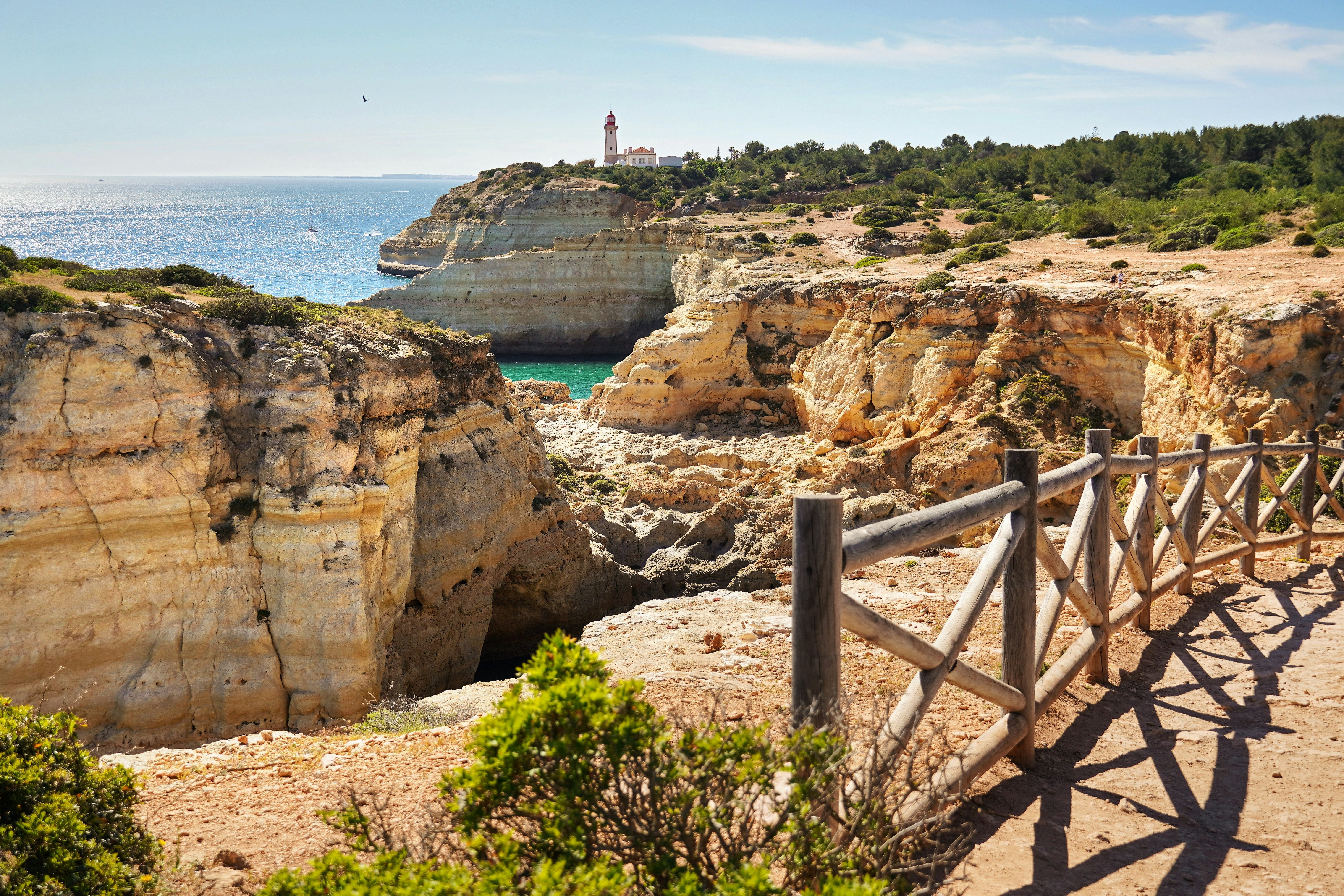
2. Seven Hanging Valleys Trail
Best cliff hike
Distance: 5.7km; one way
Estimated time to complete: 2–3 hours
Level of difficulty: moderate
It is hardly a surprise to find one of Portugal’s loveliest seaside walks on the central coast of the Algarve. Multicolored rock formations, salt-tinged air and crashing waves set the scene along the wave-lashed cliffs.
While the light is most impressive in the early morning or late in the day, there’s truly no bad time to set out on this hike. Even if you start in the midday heat, you can cool off at beaches along the way (if you are walking east, hold out for Praia da Marinha at the end).
Don’t miss: The trail is rich with photo opportunities, like the lighthouse at Alfanzina and the wind-carved arches jutting into the ocean at Praia da Mesquita. The walk also passes over the Benagil Caves: if you want to see the spectacular interior, head down to Praia de Benagil, where you can arrange a boat trip.
Planning tip: After you’ve done the one-way hike, take a short taxi or Uber ride back to your starting point.
Advertisement

3. Rocha da Pena circuit
Best short hike for bird-watching and wildflowers
Distance: 6.6km (4.1 miles); round trip
Estimated time to complete: 2–3 hours
Level of difficulty: moderate
The Serra do Caldeirão’s most worthwhile short walk is to this limestone escarpment via a well-posted circuit that brims with natural beauty. The area has 450 plant species, including native daffodils and bee orchids. Among the birdlife you might see are the short-toed snake eagle, Iberian green woodpecker and Egyptian vulture.
Museums in Salir, Alte and Querença stock a basic map of the area. Carry water and snacks (the only refreshment stops are small shops and cafes at the base and in the village of Pena), and heed seasonal forest fire warnings. Rocha da Pena is also popular with rock climbers.
Don’t miss: The optional detour up to Talefe, the highest point in Rocha da Pena at 479m (1571ft), has mesmerizing views over the Algarve’s hinterlands.
Planning tip: While you can take two buses to reach the Serra do Caldeirão from Faro, the travel time can take over 2 hours. It’s best to take a taxi or your own car on the 37km, 40-minute drive.


4. Piódão to Foz d’Égua
Best hike from village to village
Distance: 6.8km; round trip
Estimated time to complete: 2 hours
Level of difficulty: moderate
Tiny Piódão sits deep in the Serra de Açor (Goshawk Mountains), a remote range of vertiginous ridges, deeply cut valleys, rivers and virgin woodland to the east of Coimbra. The village itself is extremely atmospheric – gray schist buildings on verdant, steeply terraced slopes – though it can get busy with tourists. To capture the region’s underlying serenity, take the short signposted trail to the nearby village of Foz d’Égua, home to some lovely old stone bridges, more schist structures and a precarious looking footbridge over the river gorge.
Don’t miss: Magnificent views over the hillside emerge on the loop back.
Planning tip: Rent a car in Coimbra for the 90-minute drive to Piódão, or catch a bus to Arganil, then second onward to Piódão. The views of the hilly countryside views along the way will dazzle.

5. Paiva walkways
Best hike in a river valley
Distance: 8km; one way
Estimated time to complete: 3 hours
Level of difficulty: moderate
In northern Portugal’s Aveiro district, staircases and walkways cling to the hillsides of a rugged valley traversed by the gurgling Rio Paiva. The river supplies welcome opportunities to cool off, with three beaches along the way. At the journey’s end (or beginning), you can make an optional visit to Ponte 516 Arouca, the world’s longest pedestrian suspension bridge.
You can start in either Areinho or Espiunca, though it’s less strenuous to begin in Areinho if you are only going one way. If you’re planning to do a round-trip hike, start in Espiunca and get the harder bits out of the way first. There are no buses here, so you’ll need your own vehicle to reach the trailhead or arrange a taxi to bring you to your starting point and pick you up.
Planning tips: Preparation is essential for this walk. It’s located in the Arouca Geopark, and you must have a (very reasonably priced) ticket. You can book in advance here.

6. Rota Vicentina
Best long-distance coastal hike
Distance: Fishermen’s Trail 226km, Historical Way 263km; both one way
Estimated time to complete: 14 days for each trail
Level of difficulty: moderate
The Rota Vicentina comprises two walking trails – one coastal and one inland – along the southwest coast to Cabo de São Vincente. Better known as the Fishermen’s Trail, the coastal walk uses paths forged over centuries by beachgoers and fisherfolk, and passes through some of Portugal’s most dramatic coastal scenery. The inland route (the Historical Way) is equally appealing. It runs through rural villages, cork tree forests and river valleys, with a scenic coastal section anchoring its southern end.
The Fishermen’s Trail has 13 sections, and the walk is slightly more difficult, with some passages on dunes and thigh-burning sands. At times it snakes along cliffs, mostly on a narrow single track, and only walkers are allowed. The Historical Way also has 13 sections but is longer and generally easier, with wider trails; mountain bikes are permitted.
Planning tip: It’s rarely more than 25km (15.5 miles) between villages, so you can leave the camping gear at home and lodge overnight at accommodations in the towns.


7. Via Algarviana
Best long-distance hike in the interior
Distance: 300km; one way
Estimated time to complete: 2–3 weeks
Level of difficulty: moderate
If you tire of lounging on the Algarve’s postcard-pretty beaches, a hike along part – or if you’re really brave, all – of the Via Algarviana will immerse you in the magnificent inland landscapes of this region.
The trail stretches from Alcoutim in the northeast to Cabo de São Vicente in the southwest. Some of the most beautiful sections are around Monchique, where splendid panoramas open around you on the climb through cork groves to the Algarve’s tallest peaks. Avoid high summer, when temperatures can be extreme and wildfires can pose a hazard.
Planning tip: For a 2-day taster, stay in Monchique, walk up to Picota and back the first day, then to Fóia and back the next.
Advertisement


