


Advertisement
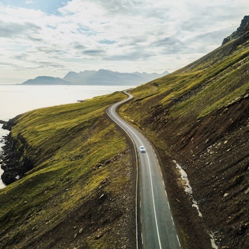
Iceland's famous Ring Road. Daniel Dorsa for Lonely Planet
Driving in Iceland is a dreamy experience, and having your own set of wheels offers the freedom to explore the country at your own pace.
Picture the scene: you’re gliding along a road curling around a snowy hillside. On your right, a steep, rocky slope, the top shrouded in fog. On your left, the surf beats against vertical cliffs, with sea birds circling overhead. Before you, the crystal blue waters of yet another fjord stretch out to the horizon.
There’s no better feeling than heading out and seeing where the road takes you. But if you require a little more structure to your overland odyssey, we’ve selected eight unforgettable Iceland road trips to get you started.
1. The Blue Diamond tourist route
Best to see volcanic activity
Advertisement
Start and finish: Keflavík International Airport
Approximate distance: 75–115km (50–70 miles)
From Keflavík International Airport, the Blue Diamond tourist route loops around the otherworldly lava landscapes of Reykjanes Peninsula, through quiet seaside villages and the wondrous Reykjanes Geopark, recognized as a UNESCO Global Geopark in 2015.
Nowhere else are the borders between the American and Eurasian tectonic plates as visible. All around are signs of geothermal and volcanic activity: the milky blue waters of the Blue Lagoon steam into the sky, while Geldingadalir (which erupted in 2021 and again in August 2022, but is now inactive) continues to wow visitors. Check safety alerts before you visit.
There are many more discoveries to be made on the route, including the windswept shore by Reykjanes Lighthouse and Kleifarvatn Lake (home, according to legend, to a wormlike monster the size of a whale), and there are myriad hiking trails.
Planning tip: You can do a round trip in less than a day, but it’s worth staying for a few days to fully explore the region.
2. Road 435
Best to experience in summer
Start and finish: Reykjavík
Approximate distance: 225km (140 miles)
For a different take on the Golden Circle – Iceland’s most popular day tour – try Nesjavallaleið (Road 435), which is open in the summer. It slings through moss-covered lava landscapes and up and down steep hills, with a breathtaking view of Þingvallavatn Lake in the distance. Along the road are quite a few marked hiking trails, beckoning road trippers to temporarily ditch the car and get up close and personal with the stunning landscape.
Puffs of steam are the telltale sign that you’re approaching Nesjavallavirkjum Power Plant and the exclusive ION Adventure Hotel. The road continues along placid lakes, including Úlfljótsvatn with a lonely church on its banks. You drive through a summer house region – where city dwellers go for weekend breaks – and then onto the main road past the perfectly circular Kerið crater lake, one of the obligatory Golden Circle stops.
After gawking at Gullfoss waterfall and spying Geysir (from which all other geysers take their name), you can drive back via Þingvellir National Park with a quick visit to the curious cave houses of Laugarvatnshellar.
Local tip: Bookworms should also consider making a stop at Gljúfrasteinn Laxness Museum in Mosfellsdalur. The museum is the former home of prominent Icelandic writer Halldór Laxness, who won the Nobel Prize for Literature in 1955.


3. Remote East Fjords drive
Best to explore Iceland's maritime heritage
Start and finish: Egilsstaðir
Approximate distance: 820km (510 miles)
Set up camp in Egilsstaðir and you’ll be in prime position to uncover the magical East Fjords. First, visit the village of Vopnafjörður, home to Selárlaug, a swimming pool on the banks of a salmon-filled river, which is also popular for fishing. In summer, you could cross the spectacular mountain pass Hellisheiði eystri (Road 917) to get here – but with its narrow and steep gravel road, it’s not for the faint-hearted.
Advertisement
Regardless, take the easy way back (Road 85 and Road 1) to Borgarfjörður eystri, and recharge at the village of Bakkagerði with a hotel and spa, puffin-watching house and popular music festival Bræðslan, held in July. It’s also a good base for hiking in the stunning surroundings, with the trek to Stórurð, a turquoise lake enclaved by massive boulders, a particularly popular route.
You must return to Egilsstaðir before moving on to the next fjords on the route: Eskifjörður and Neskaupstaður. Here, the maritime heritage of this region is honored in elegantly renovated historic houses: Randulfssjóhús in Eskifjörður and Beituskúrinn in Neskaupstaður, both of which now function as excellent, atmospheric restaurants.
Drive back through Fáskrúðsfjörður to Stöðvarfjörður, where Petra’s Stone Collection museum amazes, showcasing the sheer variety of minerals that can be found in the mountains in the country’s east. From here, it’s a straight run back to Egilsstaðir for the last time – remember to watch out for reindeer!
4. The Westfjords by road and ferry
Best for beautiful scenery
Start and finish: Reykjavík
Approximate distance: 765km (475 miles)
On the way to the Westfjords from Reykjavík, you’ll drive through the rural region of Dalir. Here, dairy farm Erpsstaðir makes for a great first pit stop on the journey, where you can learn about traditional farming life and sample homemade cheeses and other treats. There are also a number of historical sites nearby, including Eiríksstaðir, a living museum about life in the Viking era, and Guðrúnarlaug, the replica of the pool where the beautiful heroine of Laxdæla saga (one of the famous medieval Icelandic sagas) used to bathe.
Leaving Dalir in the rearview mirror, the first Westfjordian town you’ll reach is Reykhólar, home to Sjávarböðin, a spa specializing in seaweed baths (said to have all manner of healing properties). From here, the drive along the peninsula’s southern coast on steep gravel roads is both awe-inspiring and borderline scary, but your reward is a stroll on red-sand beach Rauðasandur and the view from Látrabjarg, Iceland’s westernmost point. Látrabjarg is also a haven for birdlife, with thousands of seabirds – including puffins, razorbills and guillemots – nesting in the cliffs.
You can take the ferry from Brjánslækur back, via Flatey, an idyllic island that seems to be frozen in time. It used to be the bustling center of the Breiðafjörður islands, but today, only seven people live there year-round. From here, the ferry takes you onward to Stykkishólmur on Snæfellsnes, via a beautiful harbor overlooked by a distant lighthouse. It’s a view that might tempt you to stay a while.
Local tip: If you have time to explore Stykkishólmur, check out the Library of Water, a modern art museum, and sample the locally sourced seafood on offer at Sjávarpakkhúsið.
5. The Snæfellsnes Peninsula
Best for varied landscapes
Start and end: Reykjavík
Approximate distance: 440km (275 miles)
In clear weather, you can see the alluring ice cap Snæfellsjökull from Reykjavík. The drive there is an adventure with ever-changing landscapes. You’ll find sand and pebble beaches, volcanoes, a glacier, rhyolite mountains, lava fields, grassy terrain, caves, bird-filled cliffs and waterfalls.
The peninsula’s southern side is graced by the white-sand beach Löngufjörur – a hot spot for horseback riding – the otherworldly lava landscape around Búðir and the many wonders of Snæfellsjökull National Park.
On the northern side, there are charming fishing villages and Kirkjufell, one of Iceland’s most photographed mountains – particularly popular when the Northern Lights are out. Although it’s possible to do a whirlwind tour of Snæfellsnes in a day, you can easily spend a few days hiking, bird watching, sailing or simply taking in the views of the immense glacier.
6. The ancient Kjölur route
Best to explore Iceland's interior
Start and finish: Reykjavík
Approximate distance: 1378km (856 miles)
You'll want at least a week for this trip as you spice up your Ring Road (Route 1) adventure by cutting through the barren interior of the country. Road 35, which splinters off from Route 1 past Gullfoss waterfall, continues along the ancient Kjölur route between glaciers Langjökull and Hofsjökull. It’s an F-road, so it requires a 4WD vehicle and is only open in the summer, but it is not as difficult as some of the other highland routes. (For example, there are no river crossings.)
Around the halfway point is Hveravellir, an oasis of sorts in the snowy desert landscape, with a lodge, a natural pool for bathing and a multicolored geothermal area with marked hiking trails, including to Kerlingarfjöll mountains. You enter the Ring Road again about an hour’s drive from Akureyri, the “capital” of the north, which is great for catching up on some culture, visiting galleries or having a night on the town (with at least three bars to choose from!).
The Ring Road will take you from fjord to fjord, past eerie mountains and into quiet seaside villages. Fáskrúðsfjörður is known for a museum that honors the legacy of French sailors, located inside the beautifully renovated French hospital. In Breiðdalsvík, drop by microbrewery Beljandi (named after a waterfall by the same name), and in Djúpivogur, take a look at the granite egg sculptures in Gleðivík by renowned artist Sigurður Guðmundsson.
7. The Diamond Circle
Best to experience North Iceland
Start and finish: Húsavík
Approximate distance: 250km (155 miles)
North Iceland’s answer to the Golden Circle is the Diamond Circle. Make your base in the whale-watching town of Húsavík and head east to Ásbyrgi at the northern realms of Vatnajökull National Park. The horseshoe-shaped canyon is characterized by vertical cliffs – walk to the top of Eyjan for an amazing view of the North Atlantic and the sand beaches to the north. This is gyrfalcon territory, so keep an eye out for the majestic raptors – the largest falcons in the world.
With its lovely lake, lava fields, steaming fumaroles and bubbling hot springs, the Mývatn area is an obligatory stop on the drive back to Húsavík. Take time to marvel at the mighty Goðafoss waterfall in Skjálfandafljót. It’s called the “waterfall of the gods” because legend has it that the lawspeaker (a role in ancient Scandinavian society where someone is entrusted to recite the law) Þorgeir Ljósvetningagoði threw his pagan sculptures into the falls after deciding that Icelanders should convert to Christianity in 1000 CE. Further upstream is Aldeyjarfoss, another spectacular waterfall surrounded by columnar basalt.
Planning tip: Don’t forget to reserve some time for Húsavík itself, a bustling town with interesting museums and fabulous seafood restaurants. Geosea Geothermal Sea Baths are perched up on Húsavíurhöfði next to a yellow lighthouse with an unobstructed view of the whale-watching boats on Skjálfandi Bay.
8. The Arctic Coast Way
Best for taking your sweet time along the coast
Start/finish: Hvammstangi – Bakkafjörður
Approximate distance: 900km (560 miles)
Designed for slow travel, the Arctic Coast Way slings along Iceland’s northern coastline, encompassing sleepy villages, six islands and amazing natural sites few people get to see. You'll get the best out of this route by planning for two weeks, starting at the seal-watching town Hvammstangi in the northwest and ending in windblown Bakkafjörður in the northeast. Along the way, you'll encounter dramatic views, lonely lighthouses and interesting stories.
At Þrístapar, you can learn about the gruesome fate of Agnes Magnúsdóttir, the heroine of Hannah Kent’s Burial Rites, who was the last woman executed in Iceland. At Brimslóð in Blönduós, there’s the option to go foraging for your dinner, and in Skagaströnd, have your fortune told at the Museum of Prophecies. In summer, the midnight sun bounces off the ocean surface, and in winter, the Northern Lights dance across the night sky in between blinking stars – far from light pollution.
Other interesting stops include the Hvítserkur sea stack, the massive Arctic Henge in Raufarhöfn – an ancient stone monument inspired by Norse mythology – and the gannet colony at Stóri Karl on Langanes.
Planning tip: Take your time to explore on foot, and book whale-watching, kayaking or diving tours for a different perspective of this wild coastal region.
Advertisement
Explore related stories


Jan 5, 20227 min read
A practical guide to living your best vanlife in Iceland: campers, routes and rules